

(NEW YORK) -- Tropical activity is ramping up in the Atlantic Basin.
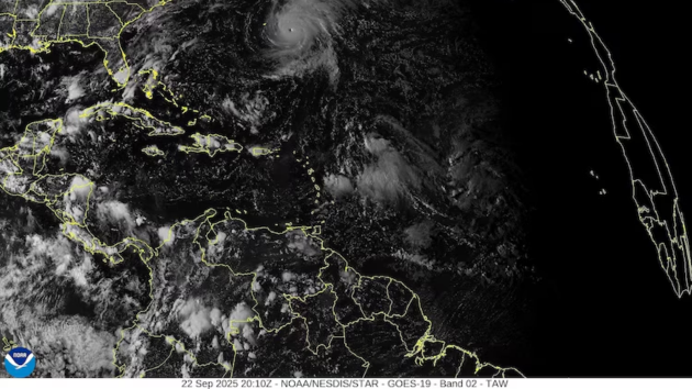
Along with Hurricane Gabrielle, which is currently tracking east of Bermuda, the National Hurricane Center is monitoring two tropical disturbances in the central Atlantic for potential development this week.
The first disturbance, located about halfway between the Lesser Antilles and the Cabo Verde Islands, now has an 80% chance of development within the next seven days, according to the latest forecast.
Shower and thunderstorm activity has increased over the past 24 hours, and environmental conditions are expected to become more favorable for development by Tuesday. The National Hurricane Center says a tropical depression is likely to form by mid to late week as the system moves west-northwestward.
Given the prevailing weather pattern, forecast guidance currently favors a track fairly similar to Gabrielle’s.
The second disturbance, a disorganized area of showers and thunderstorms, is currently situated several hundred miles east of the Lesser Antilles, west of the first system. Slow development is possible over the coming days as environmental conditions gradually become more favorable.
A tropical depression could form late this week as the system moves into the southwestern Atlantic Ocean, according to the National Hurricane Center. It currently has a 50% chance of development within the next seven days.
Regardless of development, the system could bring a period of gusty winds and showers to the Leeward Islands early this week as it tracks to the west-northwest.
The next tropical depression to form would be upgraded to a tropical storm once maximum sustained winds reach at least 39 mph, at which point it would receive a name. The next name on the list is Humberto.
Gabrielle’s development marked the end of a notably quiet period in the Atlantic Basin, a stretch that included the climatological peak of the hurricane season on Sept. 10.
Tropical activity is expected to continue increasing in the coming weeks as conditions become more favorable for development, forecasters say.
According to NOAA’s Climate Prediction Center, the odds of tropical development are increasing across parts of the Atlantic Basin as large-scale environmental conditions become more conducive, a trend likely to continue into early October.
Experts at Colorado State University echo that forecast, noting that shifts in wind patterns and other atmospheric factors could support a noticeable uptick in activity.
While the climatological peak of the Atlantic hurricane season has passed, roughly 60% of tropical activity typically occurs after Sept. 10, on average, according to the National Hurricane Center.
Historically speaking, about two-thirds of all Atlantic hurricane season activity occurs between Aug. 20 and Oct. 10.
Last year demonstrated that late September and early October can be an active period for tropical development, with multiple threats that may be high-impact and potentially devastating.
Copyright © 2025, ABC Audio. All rights reserved.