(NEW YORK) -- Hurricane Melissa, now a powerful Category 5 storm, will slam into Jamaica on Monday as the worst storm the island has ever seen.
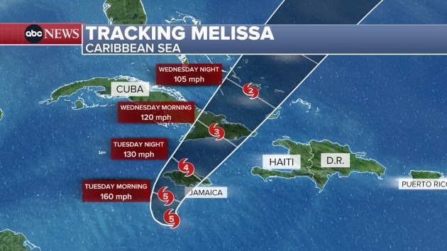
Here is Melissa’s forecasted path:
Melissa is expected to make landfall in central or western Jamaica late Monday night or early Tuesday morning, likely as a Category 4 or 5 hurricane. Most of the destruction will unfold from noon on Monday to noon on Tuesday.
Tropical storm-force winds are already underway and will steadily increase throughout the day. Winds are expected to reach hurricane strength by Monday night and will last through Tuesday afternoon.
The rain and storm surge will be even more dangerous than the wind for some. Melissa is moving very slowly, so it will bring a deluge of rain to Jamaica, with totals forecast to reach 15 to 30 inches and even up to 40 inches in localized areas. This will spark catastrophic and life-threatening flash flooding on Monday and Tuesday.
Storm surge will decimate parts of the southern coast with water surging up to 13 feet above ground level.
Next, the heavy rain will move to Haiti and the Dominican Republic, where 8 to 16 inches of rainfall is possible. Catastrophic flash flooding and landslides are also in the forecast.
Melissa will then hit southeastern Cuba on Tuesday night and Wednesday morning as a major hurricane, dumping 10 to 20 inches of rain and leading to catastrophic flooding and numerous landslides.
On Wednesday, the southeastern Bahamas will see rain totals of 4 to 8 inches, hurricane-force winds and life-threatening storm surge.
Melissa may still be a Category 1 hurricane on Thursday night or Friday morning when it passes near or over Bermuda.
Copyright © 2025, ABC Audio. All rights reserved.

