

(NEW YORK) -- A storm system closing in from the Atlantic Ocean is expected to become Tropical Storm Imelda by the end of this weekend, and could bring storm surges and high winds to the southeast U.S. coastline early next week.
The storm -- officially called Tropical Depression Nine as of Saturday morning -- was earlier located northwest of the eastern tip of Cuba, moving northwest at around 7 mph and forecast to cross the central and northwestern Bahamas this weekend, the National Hurricane Center said.
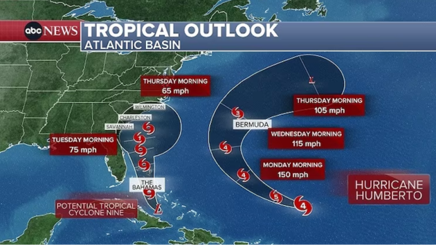
The storm is expected to approach the southeastern U.S. coast early next week. A tropical storm warning is in effect for the central and northwestern Bahamas.
The NHC issued a Tropical Storm Watch Saturday for the east coast of central Florida from the Palm Beach-Martin County line northward to the Flagler-Volusia County line.
Tropical Depression Nine is expected to become a tropical storm around Saturday night or early Sunday. When it becomes a tropical storm, it will take the name Imelda.
Rain associated with the storm is expected to impact eastern Cuba, Hispaniola, Jamaica and the Bahamas, with flash and urban flooding forecast through the weekend, the NHC said. Mudslides are possible in higher terrain, it added.
Expected rainfall is around 4 to 8 inches for the Bahamas, 8 to 12 inches and localized totals up to 16 inches for eastern Cuba, and 2 to 4 inches of additional rain for other parts of Cuba, as well as Jamaica and Hispaniola.
Up to 3 feet of storm surge is also expected for the coastlines in the northwestern Bahamas.
As the system approaches the U.S., coastal Georgia, the Carolinas and mid-Atlantic states may all see flash, urban and river flooding, the NHC said.
The storm is expected to be at or near Category 1 hurricane intensity when it approaches the U.S. coast early next week, the NHC said, bringing storm surge and wind.
In an afternoon press conference, South Carolina Governor Henry McMaster said the state has "no intention" of issuing any mandatory evacuation orders for the upcoming storm, but that people should not "be misled."
"We know that we're going to have high winds, we know that we're going to have a lot of water," the governor said.
McMaster also invoked the one-year anniversary of Hurricane Helene to compare it to the uncertainty of this storm.
"We remember that it did not go exactly where it was expected to go," McMaster said. "This storm does not look as strong as it looked yesterday, but that could change tonight."
The governor said he is "expecting" the federal government to cooperate with them, "one hundred percent," and that yesterday's emergency declaration was to begin putting people and equipment in the right places, including helicopters and aerial resources.
"The good news is the storm will probably stay out in the ocean," McMaster said, while still cautioning people to be prepared. "Don't drive through standing water… we lose a lot of people through drowning," the governor said, calling that "pitiful."
Meanwhile, Hurricane Humberto has rapidly intensified to become the third major hurricane of the 2025 Atlantic hurricane season. The NHC said Saturday that Humberto is expected to "remain a powerful major hurricane through early next week."
Humberto is still expected to track west of Bermuda on Tuesday through Wednesday and stay hundreds of miles west of the U.S., eventually turning northeast and back out to sea without a landfall.
Swells generated by the hurricane will begin affecting portions of the northern Leeward Islands, the Virgin Islands, Puerto Rico and Bermuda this weekend, the NHC said in its latest update.
Copyright © 2025, ABC Audio. All rights reserved.