

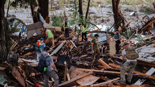
(NEW YORK) -- The risk of the catastrophic flooding that struck Texas Hill Country as people slept on July 4 and left at least 120 dead was potentially underestimated by federal authorities, according to an ABC News analysis of Federal Emergency Management Agency data, satellite imagery and risk modeling.
Some of the youth camps and recreational areas most devastated by the extreme weather were established on land designated by the FEMA as "special flood hazard areas" or in the river's floodway, making them especially vulnerable to the July 4 flash floods that exceeded some federal estimates for a worst-case scenario.
At some points, water extended for hundreds of feet outside the Guadalupe River's banks and beyond FEMA estimates, according to satellite data. First Street, a risk modeling company, told ABC News that the company believes that more than double the 8 million homes nationwide that are designated by FEMA to be in flood zones are actually at risk, finding that government models are outdated and fail to consider extreme weather events.
Devastated camp 'predominantly in a flood zone'
Along the river banks in Kerr County, the all-girls Camp Mystic was overrun by flood waters, which claimed the lives of 27 campers and counselors and swept multiple buildings from their foundations. According to FEMA maps, more than a dozen of the 36 cabins were located within areas designated as high risk for potential flooding on the river and nearby Cypress Creek.
"We knew this camp was predominantly in a flood zone, and even the areas that we showed that were outside were right on the edge of a flood zone," said Jeremy Porter, the head of climate implications research at First Street, which provides climate data for companies like Zillow and Redfin.
Multiple buildings at Camp Mystic, including four cabins, were built within the Guadalupe River's "regulatory floodway," where most new construction is severely limited due to flood risk and to "protect human life and health," according to Kerr County's Flood Damage Prevention Order from 2020. The document noted that the stretch of land where Camp Mystic is situated is "an extremely hazardous area due to the velocity of flood waters which carry debris, potential projectiles and erosion potential."
An additional 12 cabins at Camp Mystic were built on land designated as "special flood hazard areas," where residents face a 1% chance of flooding annually and are normally required to have flood insurance.
"These should guide where you should or should not construct, whether you should have mitigation processes in place, like putting homes on elevated beds," said Jonathan Sury, a senior staff associate at the National Center for Disaster Preparedness at Columbia University in Manhattan.
But some of those structures at the nearly 100-year-old camp were built decades before FEMA began issuing its flood maps in the 1960s and were likely permitted to remain despite modern construction regulations, Porter noted.
A row of cabins at Camp Mystic sat directly behind the "special flood hazard area" and was deemed a lower risk for typical flooding. However, the extreme flash-flooding over Independence Day weekend inundated even the area thought to be at lower risk for flooding, satellite and radar analysis show.
'Outdated' maps
At its maximum point, the floodwaters were recorded to be more than 500 feet from the Guadalupe River banks, and more than 200 feet from the edge of the FEMA Special Flood Hazard Area, according to the satellite data. The satellite data was collected and provided to ABC News by ICEYE, a company operating synthetic aperture radar satellites, which can obtain real-time data worldwide by using radar pulses to generate data. The data collected measures the depth of the water in a given location.
Other areas along the Guadalupe River were not only vulnerable to flooding but also saw a higher-than-expected water level, exceeding the area marked for a 0.2% annual chance of inundation. Experts told ABC News that Texas practices "very little oversight" over youth camps, and state officials last week approved Camp Mystic's emergency plans.
At the Heart O' the Hills Camp for Girls – where 1 person was killed – at least seven structures were built in the Special Flood Hazard Area. The data shows that the floodwater reached up to 220 feet from the riverbed.
Floodwaters devastated RV parks north of the other camps on the Guadalupe River. More than 60 RV spots had been situated in the FEMA-designated Special Flood Hazard Area. Satellite data shows the area was covered in floodwater spanning the entire RV park.
Lorena Guillen, the owner of the Blue Oak RV Park, told ABC News that she was familiar with where her business fell on the FEMA flood map and never considered that the floodwaters could reach as far as they did last week.
"It's always come up…but there was nothing that would give us an indication that the flood was going to get all the way up 35, 40 feet high in 40 minutes," she said. "Everything is gone. And there is so much debris, so much cleanup to do that it is going to take, it's going to take months and months."
Requests for comment to the camps and FEMA were not immediately answered.
"Our City of Kerrville and Kerr County leadership are committed to a transparent and full review of processes and protocols," the Kerr County Joint Information Center said in an email. "The special session [of the state legislature] will be a starting point in which we will begin this work, but our entire focus since day one has been rescue and reunification."
According to Porter, the extent of the flooding at Camp Mystic and other areas is representative of a broader problem with FEMA's modeling, which places 8 million properties across the country at risk of a 100-year flood.
FEMA's flood maps are generally used by the government to determine what insurance requirements are needed for homeowners, according to Lidia Cano Pecharroman, a researcher at MIT Department of Urban Studies and Planning."When planning for flooding we cannot be over-reliant on these maps," she said. "They are a useful tool but they are based on limited modeling and data."
FEMA's model considers factors like coastal storm surge and risks of flooding along river channels, but does not take into account heavy precipitation, such as the extreme rains that swept across Texas last week, Porter said.
"They're outdated in the sense that they're not climate corrected," Porter said. "As those intensities increase of those rainfall events, we're getting more rainfall happening all at once. It's filling the waterways, and we're seeing rapid increases in the river levels."
First Street estimates that there are more than 2.2 times the number of properties at risk of hundred-year floods than FEMA's model suggests.
"It's a devastating event that occurred, but people should look at it and say, you know, if we know our risk, we should retrofit our buildings," said Porter. "We should make sure that they're designed to a standard that can withstand the risk that exists in an area right outside of that flood zone."
Copyright © 2025, ABC Audio. All rights reserved.