


(NEW YORK) -- California was once the site of a gold rush.
But now arguably one of the most precious commodities in parts of the state and in the Southwest is something else entirely -- water -- as the region grapples with a decades-long megadrought that experts say has been spurred on by a warming Earth.
Farmers struggle to water their crops. Less snowpack feeds rivers, streams and lakes in areas surrounding the mountains. And what little runoff there is from snow in the spring is immediately sopped up by the arid soil before it can reach important bodies of water.
A February report from the California State Water Resources Control Board, for instance, said the question is not whether warming will occur, but the "magnitude of warming" instead and says the state is facing the "threat of greater scarcity of water supplies, increased water demand, and limited water supply reliability." The report said the state said it has taken "bold" actions to reduce the effects of climate change as well as increase water resilience such as the expansion of recycled water.
And the Southern Nevada Water Authority, which gets 90% of its water from the Colorado River, acknowledges it is "facing the worst drought in the basin's recorded history" and has been working to address the drought's impact on water supply for 20 years, including using 23 billion fewer gallons in 2020 than 2002, despite a massive population growth.
Water levels in major bodies of water in the Southwest -- both natural and manmade -- are approaching historic lows as the drought is exacerbated by heatwave after heatwave during a dry season that started earlier this year.
"The American Southwest has always been at risk for this, but climate change even pushes that risk much, much higher," Brad Udall, climate research scientists at Colorado State University's Colorado Water Institute, told ABC News.
While some water variation level is cyclical, experts fear that prolonged warming, combined with diversion and other human activities, are putting the region at risk. The Southwest is "particularly dependent" on surface water, so "even a small increase in temperature -- which drives evaporation -- or a decrease in precipitation in this already arid region can seriously threaten natural systems and society," the Environmental Protection Agency said.
The region, which is normally hot and dry, has experienced temperatures above the long-term average, with some areas 2 degrees warmer, over the past 20 years and some parts are "experiencing long-term reductions in mountain snowpack," according to the EPA.
The depletion of these water sources could be disastrous as it affects the supply for drinking for tens of millions of people and agriculture, ruins local biodiversity by eliminating crucial habitat and negatively impacts billion-dollar economies, experts say.
Here is how the ongoing megadrought is affecting five major bodies of water in the West:
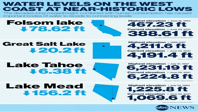
Lake Mead, Nevada and Arizona
Earlier this month, Lake Mead, the massive reservoir formed by the Hoover Dam on the Colorado River, hit its lowest water levels since the lake was created in 1935.
Water levels at Lake Mead -- and Lake Powell on the other side of the Grand Canyon, the second-largest reservoir in the U.S. -- are headed toward being 30% less than what they were 20 years ago at the start of the most recent warming period, Udall said.
"There are huge, big bathtub rings very visible at both Lake Mead and Lake Powell," Udall said, referring to previous high water levels.
Minor cutbacks in water deliveries are expected next year if water levels in Lake Mead do not rebound. Another couple of bad years would result in a "major shortage," Udall said.
If water levels drop low enough, it would be the first-ever official water shortage declared in Arizona and Nevada, and the governments could order cutbacks.
Folsom Lake, California
One of California's largest reservoirs, Folsom Lake, is crucial to providing water to the more than 40 million residents in the Golden State but is also in danger of drying up.
Severe drought conditions in the West have left barely any snowpack on the neighboring Sierra Nevada Mountains, contributing to record lows in the reservoir, which is used for drinking water, fisheries in the American River, which feeds the lake, and farming and agricultural purposes, Rich Preston-Lemay, the sector superintendent for Folsom Lake Park, told ABC News.
The lake is 68 feet lower than it was last year -- the equivalent of a five-story building, ABC San Francisco station KGO reported earlier this month. Memorial Day visitors were surprised to find that only one of the lake's 13 boat ramps was operating over the holiday weekend, the station said, and there has been zero precipitation so far in June, according to the Bureau of Reclamation.
The water has receded so much that a plane that crashed in 1986 was visible from the bottom of the lake, the Placer County Sheriff's Office announced on June 16. Despite the drought, the lake is not at a record low. That came in 1977 after the Great Drought at 347.57 feet. Its current elevation is 388.61 feet.
Officials are in a "race against time" to protect communities and other natural resources from the effects of climate change, California Natural Resources Secretary Wade Crowfoot told ABC News.
"Climate change impacts have become a matter of protecting communities in California -- worsening wildfire risk, worsening drought, extreme heat," he continued. "We used to think about preparing for climate change impacts as sort of a future planning exercise for coming decades. Now, we're actually responding to it as the public safety imperative."
Lake Tahoe, Northern California and Nevada
Variability in water levels is typical at Lake Tahoe, a 22-mile-long and 12-mile-wide lake on the border of California and Nevada -- dropping during the summer and rising during the early part of the year, Geoffrey Schladow, director of the Tahoe Environmental Research Center at the University of California, Davis, told ABC News.
But the combination of less snowpack, drought and increased usage by humans has left the water just about 2 1/2 feet above the natural rim of the lake at the start of the dry season -- and it will only continue to empty as the season goes on, Schladow said.
Come October, the water will likely be at the rim, which means water will no longer naturally flow out of the lake and into the Truckee River, the sole outlet of Tahoe and an important source of irrigation along adjacent valleys, Schladow said. The Truckee River also feeds into Pyramid Lake, which supplies water for the city of Reno.
The water level was already lower due to a relatively dry year in 2020 that added little volume to the lake, Schladow added.
In May, water levels in Lake Tahoe were so low that some boats could not be launched from ramps and docks. The City of South Lake Tahoe even closed a boat ramp to motorized boaters for 2021 due to the low levels, ABC Sacramento affiliate KXTV reported.
Despite the drop, the communities surrounding Tahoe likely won't suffer as much as those who depend on reservoirs elsewhere in the West that supply water to millions of people, Schladow said. Lake Tahoe, by contrast, is massive and serves just tens of thousands of residents, rather than millions.
Scientists and lawmakers who monitor the lake are not yet overly concerned about the water levels in Tahoe because fluctuations are normal -- the last time water levels went below the rim was in 2016. However, if the trend were to continue over the next few years, and the region continues to experience dry winters, concerns may be raised, Schladow said.
"We're not in any imminent or real danger of not being able to supply in basin water needs, at least not for the next few years," he said.
Great Salt Lake, Utah
The Great Salt Lake, the largest saltwater lake in the world and the eight-largest terminal lake -- with no natural outlets -- has lost at least half of its water since the first settlers arrived in the region in 1847, a 2017 study published in Nature Geoscience found.
The decline is mostly a result of humans redirecting the water from streams and rivers that feed the lake for use in homes, farms and industries, the study found, with levels dropping 11 feet over the past 150 years -- despite a peak elevation of 4,211.6 feet in 1986-87. The usage has been aggravated by drought and climate change, leaving water levels at near-historic lows, Laura Vernon, Great Salt Lake Coordinator for the Utah Department of Natural Resources, told ABC News.
The lake levels are currently at three-tenths of a foot away from the historic low set in 1963, Vernon said, adding that she expects that barrier to be broken within weeks. Experts and lawmakers in the region are currently coming to terms with "what that means exactly," she added.
The drops are even more significant considering the size of the lake. At 1,700 square miles, "it takes a lot of water to make a change," Vernon said, adding that it was likely "something continuous over time" to make a difference in the water levels.
The economic impacts of a drying Great Salt Lake could be devastating. In 2012, the Salt Lake Advisory Council valued the annual economic industry from the lake at $1.3 billion, Vernon said. Depending on how low the water levels were to get, there could be a $1.69 billion to $2.17 billion economic loss every year for the brine shrimp harvesting and mineral operations, the products of which would dwindle as the lake recedes, she added.
The skiing industry could be affected as well, as the lake effect snow that is created as a result of the moisture over the lake would cease to exist, Vernon said. And if the snowpack on the mountains doesn't stay frozen, it will all rush down at once and fail to consistently provide water to the surrounding communities, Vernon said.
Human health can take a toll as well as water recedes, exposing more of the lake bed embedded with decades worth of heavy metals and toxic substances within the sediment. When the bed dust is exposed for long periods of time, the particles can end up in the air and can pose a danger as residents breathe it in, experts say.
The biodiversity the lake promotes would dwindle as well. About 10 million birds stop over at the lake every year to rest and feed during their migration routes -- such as the Pacific Flyway route before they head to South America, Vernon said.
Colorado River
Water flow in the Colorado River, which supplies water to more than 40 million people and feeds into the two largest reservoirs in the country -- Lake Mead and Lake Powell -- has decreased by about 20% over the last 100 years, according to a 2020 study by U.S. Geological Survey scientists,
Several scientific papers published in recent years point to human causes for about half of the decline in river flows. The other half is attributed to warmer temperatures, which then lead to higher evaporation and water use by plants, Udall said.
"And if that evaporation goes up slightly, river flow and decline precipitously," Udall said. "So, roughly speaking, a 1% increase in evaporation can lead to a 5% decrease in river flow."
The Colorado River system is one of the most important in the country. As the river begins in the Rocky Mountains and wraps across the Southwest before it feeds into the Gulf of California, water is diverted to major cities such as Denver, Los Angeles, Las Vegas, Phoenix, Tucson, San Diego and farms to the south in Mexico. About a quarter of the water in Lake Mead and Lake Powell comes out of the Colorado River system, Udall said.
Recent droughts have been so severe that even in years when the Rocky Mountains experience a high snow pack, the arid soil in the region is so parched that it absorbs up any moisture as soon as it melts and flows down, Udall said.
For instance, in any given year, 50% the water from a full snowpack would be expected to be runoff, Udall said. Despite the warming temperatures, the region saw an 85% snowpack last year -- described by Udall as "not a bad year." But only about 30% of runoff water made it to the river, Udall said.
"On any given day, it's now likely to be hotter. We have a longer growing season, so more days for it to be hot. And the atmosphere, because it's warmer, actually wants to absorb or suck up more moisture," Udall said.
The new trends are "basically our future," Udall said, adding that scientists have predicted a worst case scenario of a 40% flow loss by 2050.
"It's very worrisome," Udall said.
ABC News' Lindsey Griswold, Anthony Rivas and Jon Schlosberg contributed to this report.
Copyright © 2021, ABC Audio. All rights reserved.